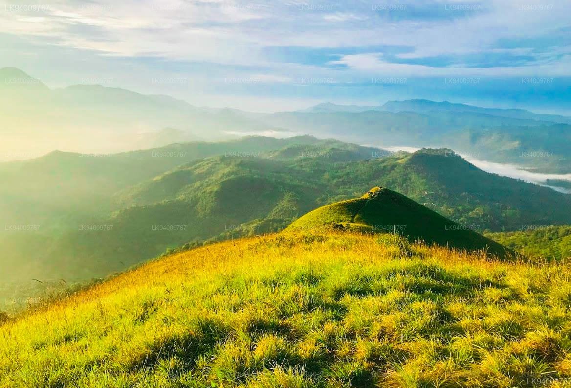
If you want to experience a trek that feels like walking along the spine of the world, the Narangala expedition is your next mandatory stop. Rising to 1,527 meters as the second-highest peak in the Uva Province, Narangala is famously known as Thanga Malai (Golden Mountain) due to the vast, golden-green mana grasslands that blanket its sharp, windswept slopes.
What sets it apart is its striking geometry—a distinct rectangular plateau that abruptly shoots up into a razor-sharp, triangular peak.
Expedition at a Glance
- Location: Near Keenakele / Hali-Ela, Badulla District, Sri Lanka
- Distance: ~6 km round trip
- Difficulty: Moderate (mostly steady inclines, but with narrow, windy ridge walks)
- Duration: 2 to 3 hours to ascend
- Best Time to Start: 5:30 AM (essential for catching the sunrise and escaping the baking midday sun)
The Route: Pipelines, Turpentine Groves, and Golden Ridges
The trail starts from the Thangamalai Estate area, right by the local Hindu temple. It offers a fast-shifting mix of terrain that will keep you on your toes:
- The Pipeline Foottrail: The hike kicks off smoothly by tracking a massive water pipeline that snakes through the vibrant, manicured tea estate rows.
- The Slippery Pine Forest: As you leave the estate, you will enter a grove of tall turpentine and pine trees. The incline gets steeper here, and the ground is notoriously treacherous due to a thick carpet of dry, slippery leaves.
- The Knife-Edge Ridge: Once you clear the forest, you step onto the open ridge. From here, you walk along a narrow, exposed spine surrounded by sweeping drops of golden grass on either side.
A Warning on the Winds: Narangala is situated right at the edge of the Uva plateau, pointing directly into a massive gap formed by the valleys of Uma Oya and Badulu Oya. Because of this unique geography, the winds at the upper ridge can be incredibly powerful and sudden. Watch your footing carefully along the edges.
The Summit Reward
Reaching the triangular peak rewards you with an unmatched 360-degree panorama. On a crisp, clear morning, you can look out across the valley to see the silhouettes of the Namunukula range, Madolsima, and even the distant floodplains stretching out toward the east.
If you hike early enough, you might witness the legendary sea of clouds phenomenon, where the valleys completely disappear beneath a thick, white ocean of mist, leaving you standing entirely above the clouds.
Quick Preparation Checklist
- Water Supply: Bring at least 2 to 2.5 liters of water per person. There are absolutely no drinkable water sources on the upper mountain or the summit.
- Wind & Sun Protection: There is zero shade once you reach the grasslands. Pack a cap, sunscreen, and a windbreaker jacket to handle the cold, howling summit winds.
- Proper Footwear: Do not attempt this in casual sandals. The combination of slippery pine needles and steep grass tracks requires shoes with aggressive grip.
The Verdict Narangala is a dream for campers and trekkers who want maximum visual payoff with a moderate physical challenge. Walking its golden, wind-scoured ridges feels like an epic highland safari, making it one of the most visually dramatic mountains you can scale in Sri Lanka.