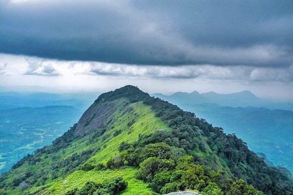
If you want a hike that combines dramatic vertical drops, gripping rock scrambles, and a deep dive into island history, it is time to face Alagalla Mountain. Towering at 1,140 meters at the border of the Central and Sabaragamuwa Provinces, this massive rock fortress is famously known as the Potato Range due to its unique, elongated shape resembling a potato.
Historically, Alagalla acted as a natural lookout and defense shield for the ancient Kandyan Kingdom. Today, it stands as a thrilling challenge for trekkers who want an intense, adrenaline-pumping ridge walk with unparalleled panoramic rewards.
Expedition at a Glance
- Location: Near Kadugannawa / Balana, Rambukkana District, Sri Lanka
- Distance: ~6 km round trip (starting from the Gangoda or Balana side)
- Difficulty: Challenging (features a near-vertical final rock climb using ropes)
- Duration: 3 to 4 hours to ascend and descend
- Best Time to Start: 6:00 AM (crucial to tackle the final exposed rock face before the stone heats up under the sun)
The Route: Tea Rows, Jungle Paths, and the Steep Scramble
Most hikers prefer the route starting near the Gangoda Railway Station. The trail keeps your heart racing as it shifts through three distinct phases:
- The Village and Tea Estate Trail: The hike begins with a steady, winding walk through local village paths and quiet tea estates. The incline is manageable here, offering beautiful views of the surrounding valleys.
- The Jungle and High Grass: As you approach the base of the massive rock outcrop, the trail cuts into a dense, shady forest patch and transitions into tall, thick mana grass. The path can get extremely narrow and overgrown here.
- The Final Vertical Rock Face: This is where the real expedition begins. The final stretch to the summit requires you to scale a near-vertical, exposed rock wall. You will need to pull yourself up using tree roots, rock crevices, and the permanent steel ropes installed at the site.
A Note on Head for Heights: The final climb to the summit is not for the faint-hearted. If you suffer from severe vertigo or are hiking during a sudden downpour, it is highly recommended to stop at the sub-summit ridge. The rock becomes incredibly slick when wet, making the climb highly hazardous.
The Summit Reward
Stepping onto the flat, windy spine of Alagalla’s peak feels like standing on top of a castle wall. The mountain drops away vertically on both sides, offering a dizzying, unobstructed 360-degree view.
On a clear day, you can watch the trains snaking along the historic steep tracks far below at the Kadugannawa pass. You will also get a perfect view of neighboring peaks like Bible Rock (Bathalegala), Utuwankanda, and the rolling hills of the Kegalle district stretching into the horizon.
Quick Preparation Checklist
- Gloves for Climbing: A simple pair of rubber-gripped gardening gloves will save your hands from rope burns and sharp rock edges during the final vertical scramble.
- Ample Hydration: Pack at least 2 liters of water. The upper rock plateau is completely exposed to the elements, and the heat can cause rapid dehydration during the climb.
- Leech Protection: The lower jungle and high grass sections are damp and heavily populated by leeches, especially after a morning mist or rain. Wear long pants and pack your choice of repellent.
The Verdict Alagalla isn't a casual weekend stroll; it is a true test of physical stamina and mental focus. If you are ready to push your boundaries, scramble up bare rock walls, and stand where ancient warriors once stood to guard a kingdom, the Alagalla expedition delivers an unforgettable rush of adventure.
